Thank you for supporting this site ❤️
Make a donation
Make a donation
Gear up for your next adventure:
As an Amazon Associate, this site earns from qualifying purchases at no extra cost to you.
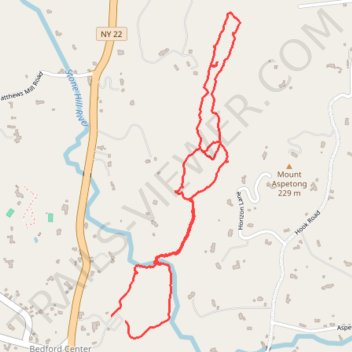
St Matthew's Woods + Ketchem Sanctuary
- Distance: 2.7 mi
- Elevation gain: 130 m
- Maximum elevation: 188 m
- Elevation loss: 126 m
- Minimum elevation: 116 m
- Moving time: 54 m 48 s
- Moving speed: 3.0 mph
- Maximum speed: 6.3 mph
- Total time: 1 h 17 s
- Global speed: 2.7 mph
Interactive trail map
Thank you for supporting this site ❤️
Make a donation
Make a donation
Gear up for your next adventure:
As an Amazon Associate, this site earns from qualifying purchases at no extra cost to you.
Trail profile
- Distance: 2.7 mi
- Elevation gain: 130 m
- Maximum elevation: 188 m
- Elevation loss: 126 m
- Minimum elevation: 116 m
- Moving time: 54 m 48 s
- Moving speed: 3.0 mph
- Maximum speed: 6.3 mph
- Total time: 1 h 17 s
- Global speed: 2.7 mph
Thank you for supporting this site ❤️
Make a donation
Make a donation
Gear up for your next adventure:
As an Amazon Associate, this site earns from qualifying purchases at no extra cost to you.
About this trail
Name: St Matthew's Woods + Ketchem Sanctuary trail, distance, elevation, map, profile, GPS track
Coordinates: 41.22050 -73.65538 41.23387 -73.64835
Thank you for supporting this site ❤️
Make a donation
Make a donation
Gear up for your next adventure:
As an Amazon Associate, this site earns from qualifying purchases at no extra cost to you.
Other hiking, mountain biking, running and outdoor activity trails
Click on a trail to view its statistics, map and profile.