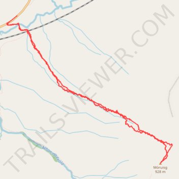
Munro Hillwalk Mòruisg
- Distance: 6.0 mi
- Elevation gain: 805 m
- Maximum elevation: 923 m
- Elevation loss: 801 m
- Minimum elevation: 150 m
- Moving time: 3 h 28 m
- Moving speed: 1.7 mph
- Maximum speed: 27.6 mph
- Total time: 4 h 3 m
- Global speed: 1.5 mph
Interactive trail map
Trail profile
- Distance: 6.0 mi
- Elevation gain: 805 m
- Maximum elevation: 923 m
- Elevation loss: 801 m
- Minimum elevation: 150 m
- Moving time: 3 h 28 m
- Moving speed: 1.7 mph
- Maximum speed: 27.6 mph
- Total time: 4 h 3 m
- Global speed: 1.5 mph
About this trail
Name: Munro Hillwalk Mòruisg trail, distance, elevation, map, profile, GPS track
Start: A890, Craig, Highland, Scotland, United Kingdom (57.51772 -5.20707)
End: A890, Craig, Highland, Scotland, United Kingdom (57.51863 -5.20479)
Coordinates: 57.49970 -5.20731 57.51863 -5.16781
Topography: Highland topographic map, elevation, terrain