Thank you for supporting this site ❤️
Make a donation
Make a donation
Gear up for your next adventure:
As an Amazon Associate, this site earns from qualifying purchases at no extra cost to you.
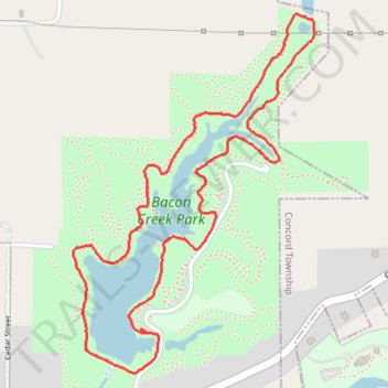
Loop walk in Bacon Creek Park
- Distance: 2.8 mi
- Elevation gain: 67 m
- Maximum elevation: 381 m
- Elevation loss: 66 m
- Minimum elevation: 364 m
- Moving time: 55 m 44 s
- Moving speed: 3.0 mph
- Maximum speed: 4.3 mph
- Total time: 55 m 44 s
- Global speed: 3.0 mph
Interactive trail map
Thank you for supporting this site ❤️
Make a donation
Make a donation
Gear up for your next adventure:
As an Amazon Associate, this site earns from qualifying purchases at no extra cost to you.
Trail profile
- Distance: 2.8 mi
- Elevation gain: 67 m
- Maximum elevation: 381 m
- Elevation loss: 66 m
- Minimum elevation: 364 m
- Moving time: 55 m 44 s
- Moving speed: 3.0 mph
- Maximum speed: 4.3 mph
- Total time: 55 m 44 s
- Global speed: 3.0 mph
Thank you for supporting this site ❤️
Make a donation
Make a donation
Gear up for your next adventure:
As an Amazon Associate, this site earns from qualifying purchases at no extra cost to you.
About this trail
Name: Loop walk in Bacon Creek Park trail, distance, elevation, map, profile, GPS track
Start: Sioux City, Woodbury County, Iowa, 51106, United States (42.49420 -96.33841)
End: Sioux City, Woodbury County, Iowa, 51106, United States (42.49429 -96.33847)
Coordinates: 42.49280 -96.34154 42.50464 -96.33072
Thank you for supporting this site ❤️
Make a donation
Make a donation
Gear up for your next adventure:
As an Amazon Associate, this site earns from qualifying purchases at no extra cost to you.