Make a donation
Gear up for your next adventure:
As an Amazon Associate, this site earns from qualifying purchases at no extra cost to you.
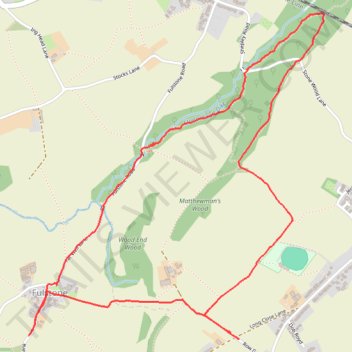
Shepley loop walk
- Distance: 3.3 mi
- Elevation gain: 108 m
- Maximum elevation: 253 m
- Elevation loss: 108 m
- Minimum elevation: 166 m
- Moving time: 1 h 43 m
- Moving speed: 1.9 mph
- Maximum speed: 3.9 mph
- Total time: 2 h 27 m
- Global speed: 1.3 mph
Interactive trail map
Make a donation
Gear up for your next adventure:
As an Amazon Associate, this site earns from qualifying purchases at no extra cost to you.
Trail profile
- Distance: 3.3 mi
- Elevation gain: 108 m
- Maximum elevation: 253 m
- Elevation loss: 108 m
- Minimum elevation: 166 m
- Moving time: 1 h 43 m
- Moving speed: 1.9 mph
- Maximum speed: 3.9 mph
- Total time: 2 h 27 m
- Global speed: 1.3 mph
Make a donation
Gear up for your next adventure:
As an Amazon Associate, this site earns from qualifying purchases at no extra cost to you.
About this trail
Name: Shepley loop walk trail, distance, elevation, map, profile, GPS track
Coordinates: 53.57958 -1.73805 53.59255 -1.71823
Topography: Kirklees topographic map, elevation, terrain
Make a donation
Gear up for your next adventure:
As an Amazon Associate, this site earns from qualifying purchases at no extra cost to you.
Other hiking, mountain biking, running and outdoor activity trails
Click on a trail to view its statistics, map and profile.
Gate Foot to Farnley Tyas via Thurstonland
United Kingdom > England > Kirklees > Kirkburton
Gate Foot - Snowgate Head - Fulstone - Biggin - Top of the Bank - Thurstonland - Top of the Hill - Farnley Tyas
Distance: 3.6 mi • Elevation gain: 142 m • Maximum elevation: 288 m