Thank you for supporting this site ❤️
Make a donation
Make a donation
Gear up for your next adventure:
As an Amazon Associate, this site earns from qualifying purchases at no extra cost to you.
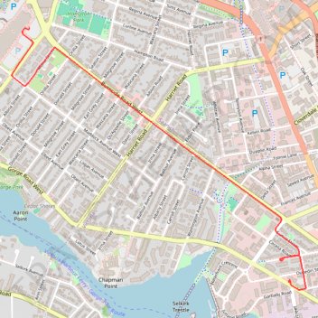
2026-04-10--23-29-02
- Distance: 2.1 mi
- Elevation gain: 33 m
- Maximum elevation: 29 m
- Elevation loss: 30 m
- Minimum elevation: 11 m
- Moving time: 8 m 49 s
- Moving speed: 14.1 mph
- Maximum speed: 29.6 mph
- Total time: 17 m 8 s
- Global speed: 7.3 mph
Interactive trail map
Thank you for supporting this site ❤️
Make a donation
Make a donation
Gear up for your next adventure:
As an Amazon Associate, this site earns from qualifying purchases at no extra cost to you.
Trail profile
- Distance: 2.1 mi
- Elevation gain: 33 m
- Maximum elevation: 29 m
- Elevation loss: 30 m
- Minimum elevation: 11 m
- Moving time: 8 m 49 s
- Moving speed: 14.1 mph
- Maximum speed: 29.6 mph
- Total time: 17 m 8 s
- Global speed: 7.3 mph
Thank you for supporting this site ❤️
Make a donation
Make a donation
Gear up for your next adventure:
As an Amazon Associate, this site earns from qualifying purchases at no extra cost to you.
About this trail
Name: 2026-04-10--23-29-02 trail, distance, elevation, map, profile, GPS track
Coordinates: 48.44048 -123.39579 48.45438 -123.37229
Thank you for supporting this site ❤️
Make a donation
Make a donation
Gear up for your next adventure:
As an Amazon Associate, this site earns from qualifying purchases at no extra cost to you.
Other hiking, mountain biking, running and outdoor activity trails
Click on a trail to view its statistics, map and profile.
2026-04-10--10-26-29
Canada > British Columbia > Cowichan Valley Regional District > Area A (Mill Bay / Malahat) > Mill Bay
Distance: 24.8 mi • Elevation gain: 774 m • Maximum elevation: 360 m