Thank you for supporting this site ❤️
Make a donation
Make a donation
Gear up for your next adventure:
As an Amazon Associate, this site earns from qualifying purchases at no extra cost to you.
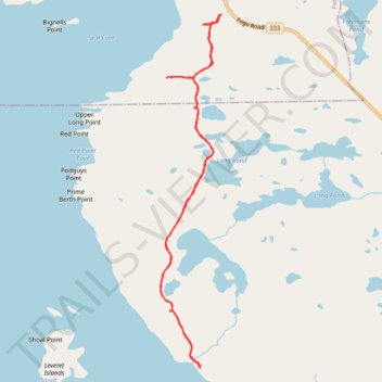
Waterman's Brook Trail
- Distance: 5.6 mi
- Elevation gain: 157 m
- Maximum elevation: 72 m
- Elevation loss: 157 m
- Minimum elevation: 1 m
- Moving time: 2 h 25 m
- Moving speed: 2.3 mph
- Maximum speed: 4.7 mph
- Total time: 2 h 42 m
- Global speed: 2.1 mph
Interactive trail map
Thank you for supporting this site ❤️
Make a donation
Make a donation
Gear up for your next adventure:
As an Amazon Associate, this site earns from qualifying purchases at no extra cost to you.
Trail profile
- Distance: 5.6 mi
- Elevation gain: 157 m
- Maximum elevation: 72 m
- Elevation loss: 157 m
- Minimum elevation: 1 m
- Moving time: 2 h 25 m
- Moving speed: 2.3 mph
- Maximum speed: 4.7 mph
- Total time: 2 h 42 m
- Global speed: 2.1 mph
Thank you for supporting this site ❤️
Make a donation
Make a donation
Gear up for your next adventure:
As an Amazon Associate, this site earns from qualifying purchases at no extra cost to you.
About this trail
Name: Waterman's Brook Trail trail, distance, elevation, map, profile, GPS track
Start: Fogo, Newfoundland, Newfoundland and Labrador, A0G 2B0, Canada (49.70960 -54.27475)
Coordinates: 49.67871 -54.28303 49.70960 -54.27475
Thank you for supporting this site ❤️
Make a donation
Make a donation
Gear up for your next adventure:
As an Amazon Associate, this site earns from qualifying purchases at no extra cost to you.