Thank you for supporting this site ❤️
Make a donation
Make a donation
Gear up for your next adventure:
As an Amazon Associate, this site earns from qualifying purchases at no extra cost to you.
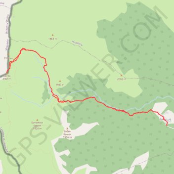
Peak Derza (2764masl.) - Korab
- Distance: 9.4 mi
- Elevation gain: 1,193 m
- Maximum elevation: 2,363 m
- Elevation loss: 1,193 m
- Minimum elevation: 1,230 m
- Moving time: 6 h 15 m
- Moving speed: 1.5 mph
- Maximum speed: 5.3 mph
- Total time: 9 h 22 m
- Global speed: 1.0 mph
Interactive trail map
Thank you for supporting this site ❤️
Make a donation
Make a donation
Gear up for your next adventure:
As an Amazon Associate, this site earns from qualifying purchases at no extra cost to you.
Trail profile
- Distance: 9.4 mi
- Elevation gain: 1,193 m
- Maximum elevation: 2,363 m
- Elevation loss: 1,193 m
- Minimum elevation: 1,230 m
- Moving time: 6 h 15 m
- Moving speed: 1.5 mph
- Maximum speed: 5.3 mph
- Total time: 9 h 22 m
- Global speed: 1.0 mph
Thank you for supporting this site ❤️
Make a donation
Make a donation
Gear up for your next adventure:
As an Amazon Associate, this site earns from qualifying purchases at no extra cost to you.
About this trail
Name: Peak Derza (2764masl.) - Korab trail, distance, elevation, map, profile, GPS track
Start: Tanushe, Municipality of Mavrovo and Rostusha, North Macedonia (41.72088 20.57294)
End: Tanushe, Municipality of Mavrovo and Rostusha, North Macedonia (41.72087 20.57297)
Coordinates: 41.72082 20.51863 41.74042 20.57326
Thank you for supporting this site ❤️
Make a donation
Make a donation
Gear up for your next adventure:
As an Amazon Associate, this site earns from qualifying purchases at no extra cost to you.