Make a donation
Gear up for your next adventure:
As an Amazon Associate, this site earns from qualifying purchases at no extra cost to you.
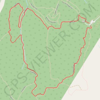
Loop hike in Hitchcock Nature Center via Badger Ridge Trail, Wildwoods, Westridge, Heritage Trail and The Chute
This loop hike at Hitchcock Nature Center provides a scenic and dynamic journey through Iowa’s Loess Hills. Traversing the Badger Ridge, Wildwoods, and Westridge trails, hikers experience a blend of open prairie views and shaded woodlands. The route, punctuated by the steep ascent of The Chute and peaceful stretches along the Heritage Trail, showcases native plant life, diverse wildlife, and sweeping panoramas, even offering distant views of the Omaha skyline on clear days. #Hiking #Loop #Forest #Nature
- Distance: 2.9 mi
- Elevation gain: 136 m
- Maximum elevation: 394 m
- Elevation loss: 135 m
- Minimum elevation: 321 m
- Moving time: 59 m 21 s
- Moving speed: 2.9 mph
- Maximum speed: 5.7 mph
- Total time: 1 h 11 m
- Global speed: 2.4 mph
Interactive trail map
Make a donation
Gear up for your next adventure:
As an Amazon Associate, this site earns from qualifying purchases at no extra cost to you.
Trail profile
- Distance: 2.9 mi
- Elevation gain: 136 m
- Maximum elevation: 394 m
- Elevation loss: 135 m
- Minimum elevation: 321 m
- Moving time: 59 m 21 s
- Moving speed: 2.9 mph
- Maximum speed: 5.7 mph
- Total time: 1 h 11 m
- Global speed: 2.4 mph
Make a donation
Gear up for your next adventure:
As an Amazon Associate, this site earns from qualifying purchases at no extra cost to you.
About this trail
Name: Loop hike in Hitchcock Nature Center via Badger Ridge Trail, Wildwoods, Westridge, Heritage Trail and The Chute trail, distance, elevation, map, profile, GPS track
Start: Badger Ridge Tail, Pottawattamie County, Iowa, 51542, United States (41.41300 -95.85784)
End: Fox Run Ridge trail, Pottawattamie County, Iowa, 51542, United States (41.41326 -95.85796)
Coordinates: 41.40550 -95.86941 41.41531 -95.85764
Make a donation
Gear up for your next adventure:
As an Amazon Associate, this site earns from qualifying purchases at no extra cost to you.
Other hiking, mountain biking, running and outdoor activity trails
Click on a trail to view its statistics, map and profile.
Loop hike in Hitchcock Nature Center via Badger Ridge Trail, Wildwoods, Westridge, Heritage Trail, Fox Run Ridge Trail and Oak Avenue Trail
United States > Iowa > Pottawattamie County
This loop hike through Hitchcock Nature Center offers a delightful blend of scenic views and diverse terrains, showcasing the unique beauty of the Loess Hills. Along the route, hikers can enjoy panoramic vistas, especially from Badger Ridge, where the rolling hills create a picturesque backdrop, and the mix of…
Distance: 5.3 mi • Elevation gain: 241 m • Maximum elevation: 397 m