Comite River Park Loop in Louisiana
The Comite River Park Loop offers a serene hiking experience with lush landscapes and scenic river views, making it a popular escape for nature lovers in the Baton Rouge area. Hikers can enjoy the tranquility of the park while keeping an eye out for diverse wildlife, although it's advisable to come prepared with bug spray due to the presence of mosquitoes along the trail. #Hiking #Loop #River #Forest #Nature
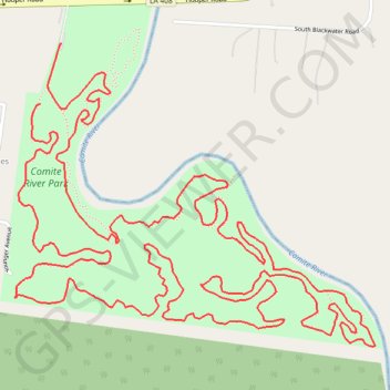
- Distance: 5.1 mi
- Elevation gain: 11 m
- Maximum elevation: 18 m
- Elevation loss: 10 m
- Minimum elevation: 12 m
- Moving time: 1 h 48 m
- Moving speed: 2.8 mph
- Maximum speed: 7.3 mph
- Total time: 1 h 56 m
- Global speed: 2.6 mph
Interactive trail map
Trail profile
- Distance: 5.1 mi
- Elevation gain: 11 m
- Maximum elevation: 18 m
- Elevation loss: 10 m
- Minimum elevation: 12 m
- Moving time: 1 h 48 m
- Moving speed: 2.8 mph
- Maximum speed: 7.3 mph
- Total time: 1 h 56 m
- Global speed: 2.6 mph
About this trail
Name: Comite River Park Loop in Louisiana trail, distance, elevation, map, profile, GPS track
Coordinates: 30.52113 -91.09846 30.52956 -91.08681