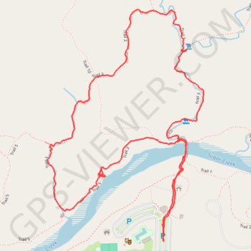
Loop Trail 3 in Turkey Run State Park
Loop Trail 3 in Turkey Run State Park offers a rugged hiking experience filled with breathtaking natural beauty. As you traverse the trail, you’ll encounter steep sandstone cliffs, picturesque canyons, and unique geological features like the Punch Bowl—a glacial pothole that showcases the area's fascinating history. This trail’s moderate difficulty and beautiful scenery make it ideal for both casual walkers and more adventurous explorers seeking a taste of Indiana's natural beauty. #Hiking #Mountain #Loop #Forest #Nature
- Distance: 2.4 mi
- Elevation gain: 97 m
- Maximum elevation: 211 m
- Elevation loss: 93 m
- Minimum elevation: 162 m
- Moving time: 1 h 14 m
- Moving speed: 1.9 mph
- Maximum speed: 10.1 mph
- Total time: 1 h 45 m
- Global speed: 1.4 mph
Interactive trail map
Trail profile
- Distance: 2.4 mi
- Elevation gain: 97 m
- Maximum elevation: 211 m
- Elevation loss: 93 m
- Minimum elevation: 162 m
- Moving time: 1 h 14 m
- Moving speed: 1.9 mph
- Maximum speed: 10.1 mph
- Total time: 1 h 45 m
- Global speed: 1.4 mph
About this trail
Name: Loop Trail 3 in Turkey Run State Park trail, distance, elevation, map, profile, GPS track
Start: Trail 1, Parke County, Indiana, 47859, United States (39.88664 -87.20056)
End: Trail 1, Parke County, Indiana, 47859, United States (39.88601 -87.20047)
Coordinates: 39.88601 -87.20588 39.89425 -87.19865
Other hiking, mountain biking, running and outdoor activity trails
Click on a trail to view its statistics, map and profile.
Ice Box, Falls Canyon, Bouder Canyon, Camel's Back, Punch Bowl, Rocky Hollow and Wedge Rock Loop from Suspension Bridge in Turkey Run State Park
United States > Indiana > Parke County
This hiking route through Turkey Run State Park, encompassing Ice Box, Falls Canyon, Boulder Canyon, Camel's Back, Punch Bowl, Rocky Hollow, and Wedge Rock Loop, offers an exhilarating experience for outdoor enthusiasts. This journey traverses rugged terrain marked by steep cliffs and unique geological…
Distance: 4.1 mi • Elevation gain: 139 m • Maximum elevation: 215 m