Stack Rock Loop Trail in Boise National Forest
Stack Rock Loop is a scenic, moderately challenging trail popular with hikers and mountain bikers alike. The route offers a mix of shaded forest areas, open meadows, and rocky outcrops, with sweeping views of Boise and the surrounding foothills. A highlight of the hike is reaching the impressive Stack Rock formation, which offers a stunning vantage point over Treasure Valley, making this trail a favorite year-round for those seeking both adventure and great photo opportunities. #Hiking #Mountain #Loop #Forest #Nature
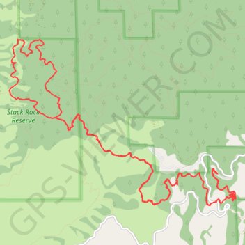
- Distance: 12.3 mi
- Elevation gain: 824 m
- Maximum elevation: 1,781 m
- Elevation loss: 823 m
- Minimum elevation: 1,623 m
- Moving time: 4 h 38 m
- Moving speed: 2.6 mph
- Maximum speed: 5.6 mph
- Total time: 5 h 10 m
- Global speed: 2.4 mph
Interactive trail map
Trail profile
- Distance: 12.3 mi
- Elevation gain: 824 m
- Maximum elevation: 1,781 m
- Elevation loss: 823 m
- Minimum elevation: 1,623 m
- Moving time: 4 h 38 m
- Moving speed: 2.6 mph
- Maximum speed: 5.6 mph
- Total time: 5 h 10 m
- Global speed: 2.4 mph
About this trail
Name: Stack Rock Loop Trail in Boise National Forest trail, distance, elevation, map, profile, GPS track
Start: #125 Freddys Stack Rock Trail, Boise County, Idaho, United States (43.73773 -116.12755)
End: #125 Freddys Stack Rock Trail, Boise County, Idaho, United States (43.73768 -116.12726)
Coordinates: 43.73351 -116.16571 43.75564 -116.12395