Indian Maiden Falls
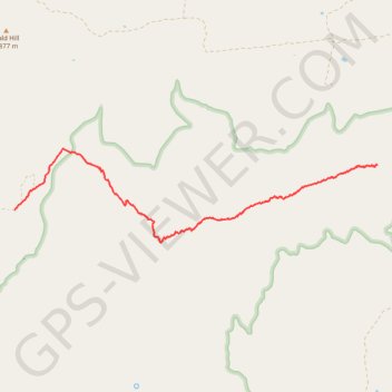
Beginning on the quiet uplands near Bald Hill, this route follows the upper West Clear Creek Trail across pinyon-juniper country toward the canyon rim before committing to the steep, loose descent through exposed slopes and a side drainage, with broad views into the deep gorge cut from the southern edge of the Colorado Plateau.
At the canyon floor, the itinerary turns upstream along West Clear Creek, where the maintained trail feel gives way to creekside route-finding among boulders, riparian shade, clear pools, slickrock shelves, red canyon walls, and unavoidable crossings.
The final approach continues through the narrower, wilder corridor beneath the high ground of Maverick Basin until Indian Maiden Falls, also known as Maiden Falls, appears as the secluded highlight of this demanding West Clear Creek Wilderness outing.
#Hiking #Backpacking #Waterfall #Canyon #Creek #Wilderness #Nature #River #Pools #Adventure
- Distance: 4.0 mi
- Elevation gain: 133 m
- Maximum elevation: 1,762 m
- Elevation loss: 563 m
- Minimum elevation: 1,258 m
- Moving time: 2 h 35 m
- Moving speed: 1.5 mph
- Maximum speed: 3.6 mph
- Total time: 5 h 49 m
- Global speed: 0.7 mph
Interactive trail map
Trail profile
- Distance: 4.0 mi
- Elevation gain: 133 m
- Maximum elevation: 1,762 m
- Elevation loss: 563 m
- Minimum elevation: 1,258 m
- Moving time: 2 h 35 m
- Moving speed: 1.5 mph
- Maximum speed: 3.6 mph
- Total time: 5 h 49 m
- Global speed: 0.7 mph
About this trail
Name: Indian Maiden Falls trail, distance, elevation, map, profile, GPS track
Start: Petes Tank, Cedar Flats, Yavapai County, Arizona, United States (34.55986 -111.63854)
End: Yavapai County, Arizona, United States (34.56463 -111.59199)
Coordinates: 34.55638 -111.63854 34.56632 -111.59194