Zeopoxa Cycling
- Distance: 6.7 mi
- Elevation gain: 157 m
- Maximum elevation: 205 m
- Elevation loss: 155 m
- Minimum elevation: 120 m
- Moving time: 1 h 15 m
- Moving speed: 5.3 mph
- Maximum speed: 12.8 mph
- Total time: 1 h 18 m
- Global speed: 5.2 mph
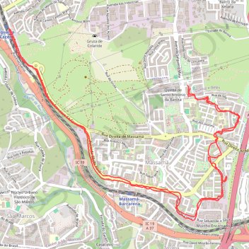
Interactive trail map
Trail profile
- Distance: 6.7 mi
- Elevation gain: 157 m
- Maximum elevation: 205 m
- Elevation loss: 155 m
- Minimum elevation: 120 m
- Moving time: 1 h 15 m
- Moving speed: 5.3 mph
- Maximum speed: 12.8 mph
- Total time: 1 h 18 m
- Global speed: 5.2 mph
About this trail
Name: Zeopoxa Cycling trail, distance, elevation, map, profile, GPS track
Start: Rua Padeira de Aljubarrota, Queluz e Belas, Sintra, Lisbon, 2605-651, Portugal (38.76095 -9.27743)
End: Rua Dona Joana, Queluz e Belas, Sintra, Lisbon, 2605-651, Portugal (38.76123 -9.27776)
Coordinates: 38.74924 -9.29812 38.76631 -9.27180
Other hiking, mountain biking, running and outdoor activity trails
Click on a trail to view its statistics, map and profile.
EuroVelo 1 (Por
Portugal > Viana do Castelo > Caminha > Terreiro
Distance: 718.6 mi • Elevation gain: 10,823 m • Maximum elevation: 254 m