Stack Rock
Dog Hike
- Distance: 1.3 mi
- Elevation gain: 88 m
- Maximum elevation: 1,317 m
- Elevation loss: 81 m
- Minimum elevation: 1,281 m
- Moving time: 31 m 7 s
- Moving speed: 2.5 mph
- Maximum speed: 10.7 mph
- Total time: 50 m 14 s
- Global speed: 1.6 mph
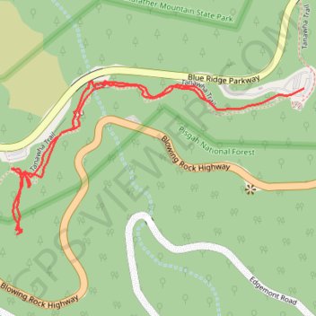
Interactive trail map
Trail profile
- Distance: 1.3 mi
- Elevation gain: 88 m
- Maximum elevation: 1,317 m
- Elevation loss: 81 m
- Minimum elevation: 1,281 m
- Moving time: 31 m 7 s
- Moving speed: 2.5 mph
- Maximum speed: 10.7 mph
- Total time: 50 m 14 s
- Global speed: 1.6 mph
About this trail
Name: Stack Rock trail, distance, elevation, map, profile, GPS track
Start: Tanawha Trail, Avery County, North Carolina, United States (36.09013 -81.81693)
End: Tanawha Trail, Avery County, North Carolina, 28616, United States (36.09040 -81.81428)
Coordinates: 36.08717 -81.82231 36.09057 -81.81428