Thank you for supporting this site ❤️
Make a donation
Make a donation
Gear up for your next adventure:
As an Amazon Associate, this site earns from qualifying purchases at no extra cost to you.
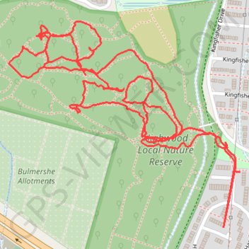
High Wood Internal Paths Woodley
Evening Walk
Woodley, Berkshire, High Wood
- Distance: 2.2 mi
- Elevation gain: 16 m
- Maximum elevation: 66 m
- Elevation loss: 17 m
- Minimum elevation: 55 m
Interactive trail map
Thank you for supporting this site ❤️
Make a donation
Make a donation
Gear up for your next adventure:
As an Amazon Associate, this site earns from qualifying purchases at no extra cost to you.
Trail profile
- Distance: 2.2 mi
- Elevation gain: 16 m
- Maximum elevation: 66 m
- Elevation loss: 17 m
- Minimum elevation: 55 m
Thank you for supporting this site ❤️
Make a donation
Make a donation
Gear up for your next adventure:
As an Amazon Associate, this site earns from qualifying purchases at no extra cost to you.
About this trail
Name: High Wood Internal Paths Woodley trail, distance, elevation, map, profile, GPS track
Coordinates: 51.44399 -0.92395 51.44815 -0.91648
Topography: Borough of Wokingham topographic map, elevation, terrain
Thank you for supporting this site ❤️
Make a donation
Make a donation
Gear up for your next adventure:
As an Amazon Associate, this site earns from qualifying purchases at no extra cost to you.