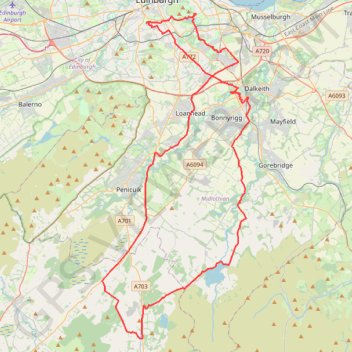
Cycleroute Edinburgh
Summer!
- Distance: 47.5 mi
- Elevation gain: 886 m
- Maximum elevation: 325 m
- Elevation loss: 891 m
- Minimum elevation: 42 m
Interactive trail map
Trail profile
- Distance: 47.5 mi
- Elevation gain: 886 m
- Maximum elevation: 325 m
- Elevation loss: 891 m
- Minimum elevation: 42 m
About this trail
Name: Cycleroute Edinburgh trail, distance, elevation, map, profile, GPS track
Coordinates: 55.72786 -3.25358 55.94430 -3.07781
Topography: City of Edinburgh topographic map, elevation, terrain
Other hiking, mountain biking, running and outdoor activity trails
Click on a trail to view its statistics, map and profile.
Ride up to Pentland Hills Regional Park
United Kingdom > Scotland > City of Edinburgh
Distance: 18.8 mi • Elevation gain: 354 m • Maximum elevation: 287 m
Gladhouse reservoir loop
United Kingdom > Scotland > Midlothian > Gladhouse
Distance: 4.8 mi • Elevation gain: 65 m • Maximum elevation: 307 m
Dalry path up
United Kingdom > Scotland > City of Edinburgh
Distance: 0.7 mi • Elevation gain: 25 m • Maximum elevation: 75 m