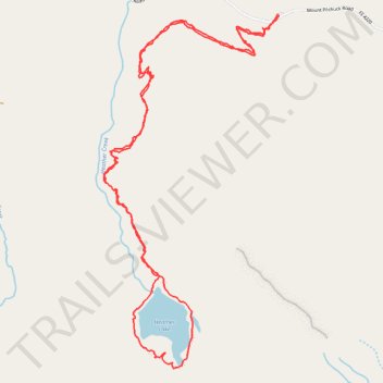
Heather Lake Loop
Interactive trail map
Trail profile
- Distance: 4.8 mi
- Elevation gain: 406 m
- Maximum elevation: 765 m
- Elevation loss: 407 m
- Minimum elevation: 426 m
- Moving time: 1 h 48 m
- Moving speed: 2.7 mph
- Maximum speed: 5.7 mph
- Total time: 1 h 53 m
- Global speed: 2.5 mph
About this trail
Name: Heather Lake Loop trail, distance, elevation, map, profile, GPS track
Coordinates: 48.06584 -121.78660 48.08304 -121.77383
Other hiking, mountain biking, running and outdoor activity trails
Click on a trail to view its statistics, map and profile.
Heather Lake Trail in Mount Baker Snoqualmie National Forest
United States > Washington > Snohomish County
Heather Lake Trail in the Mount Baker-Snoqualmie National Forest offers hikers a journey through diverse landscapes, beginning in dense second-growth forest adorned with remnants of ancient cedar stumps, relics from past logging activities. As the trail ascends, it transitions into lush old-growth woodland,…
Distance: 4.9 mi • Elevation gain: 402 m • Maximum elevation: 766 m
Northern part of the Pacific Crest Trail (PCT)
United States > Oregon > Klamath County
Hike on the Pacific Crest National Scenic Trail from Crater Lake to Canada Border through Oregon and Washington along the Sierra Nevada and Cascade mountain ranges. #Hiking #Mountain #SierraNevada #Cascade #Nature #Forest #Park #PCT
Distance: 744.6 mi • Elevation gain: 44,308 m • Maximum elevation: 2,307 m
Heather Lake Trail
United States > Washington > Snohomish County > Verlot
Distance: 5.3 mi • Elevation gain: 435 m • Maximum elevation: 766 m