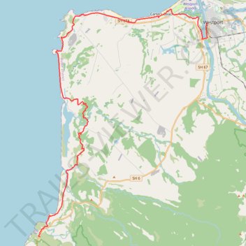
Kawatiri Coastal Trail from Charleston to Westport
- Distance: 26.0 mi
- Elevation gain: 363 m
- Maximum elevation: 53 m
- Elevation loss: 383 m
- Minimum elevation: 0 m
- Moving time: 2 h 17 m
- Moving speed: 11.4 mph
- Maximum speed: 25.6 mph
- Total time: 2 h 22 m
- Global speed: 11.0 mph
Interactive trail map
Trail profile
- Distance: 26.0 mi
- Elevation gain: 363 m
- Maximum elevation: 53 m
- Elevation loss: 383 m
- Minimum elevation: 0 m
- Moving time: 2 h 17 m
- Moving speed: 11.4 mph
- Maximum speed: 25.6 mph
- Total time: 2 h 22 m
- Global speed: 11.0 mph
About this trail
Name: Kawatiri Coastal Trail from Charleston to Westport trail, distance, elevation, map, profile, GPS track
Start: 7356, State Highway 6, Charleston, Buller District, West Coast, New Zealand (-41.90642 171.43890)
End: 2, Brougham Street, Buller District, West Coast, 7866, New Zealand (-41.75541 171.59841)
Coordinates: -41.90657 171.43768 -41.74516 171.59841
Other hiking, mountain biking, running and outdoor activity trails
Click on a trail to view its statistics, map and profile.
Kawatiri Coastal Trail from Westport to Charleston
New Zealand > West Coast > Buller District
Distance: 26.1 mi • Elevation gain: 376 m • Maximum elevation: 53 m