Make a donation
Gear up for your next adventure:
As an Amazon Associate, this site earns from qualifying purchases at no extra cost to you.
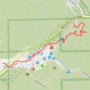
Ecology Trail, Botany Trail and Heritage Trail in Placerita Canyon Nature Center
- Distance: 0.9 mi
- Elevation gain: 22 m
- Maximum elevation: 508 m
- Elevation loss: 51 m
- Minimum elevation: 467 m
- Moving time: 28 m 12 s
- Moving speed: 1.8 mph
- Maximum speed: 4.1 mph
- Total time: 59 m 46 s
- Global speed: 0.9 mph
Interactive trail map
Make a donation
Gear up for your next adventure:
As an Amazon Associate, this site earns from qualifying purchases at no extra cost to you.
Trail profile
- Distance: 0.9 mi
- Elevation gain: 22 m
- Maximum elevation: 508 m
- Elevation loss: 51 m
- Minimum elevation: 467 m
- Moving time: 28 m 12 s
- Moving speed: 1.8 mph
- Maximum speed: 4.1 mph
- Total time: 59 m 46 s
- Global speed: 0.9 mph
Make a donation
Gear up for your next adventure:
As an Amazon Associate, this site earns from qualifying purchases at no extra cost to you.
About this trail
Name: Ecology Trail, Botany Trail and Heritage Trail in Placerita Canyon Nature Center trail, distance, elevation, map, profile, GPS track
Start: Ecology Trail, Los Angeles County, California, 01387, United States (34.37998 -118.46537)
End: Heritage Trail, Los Angeles County, California, 01387, United States (34.37711 -118.47160)
Coordinates: 34.37684 -118.47160 34.38005 -118.46428
Make a donation
Gear up for your next adventure:
As an Amazon Associate, this site earns from qualifying purchases at no extra cost to you.
Other hiking, mountain biking, running and outdoor activity trails
Click on a trail to view its statistics, map and profile.
Placerita Canyon Ecology Loop Trail
United States > California > Los Angeles County
Distance: 1.0 mi • Elevation gain: 44 m • Maximum elevation: 503 m