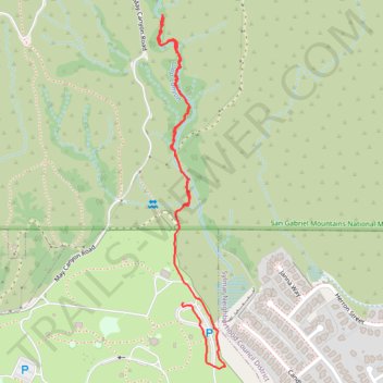
Loop Canyon - Angeles National Forest
- Distance: 1.4 mi
- Elevation gain: 85 m
- Maximum elevation: 606 m
- Elevation loss: 90 m
- Minimum elevation: 525 m
- Moving time: 44 m 57 s
- Moving speed: 1.9 mph
- Maximum speed: 4.0 mph
- Total time: 1 h 17 m
- Global speed: 1.1 mph
Interactive trail map
Trail profile
- Distance: 1.4 mi
- Elevation gain: 85 m
- Maximum elevation: 606 m
- Elevation loss: 90 m
- Minimum elevation: 525 m
- Moving time: 44 m 57 s
- Moving speed: 1.9 mph
- Maximum speed: 4.0 mph
- Total time: 1 h 17 m
- Global speed: 1.1 mph
About this trail
Name: Loop Canyon - Angeles National Forest trail, distance, elevation, map, profile, GPS track
Coordinates: 34.32638 -118.41542 34.33530 -118.41336