Ein Bokek
עין בוקק, מעלה זדון ומעלה יזרח
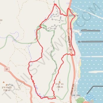
- Distance: 12.4 mi
- Elevation gain: 712 m
- Maximum elevation: 65 m
- Elevation loss: 715 m
- Minimum elevation: -386 m
- Moving time: 6 h 21 m
- Moving speed: 2.0 mph
- Maximum speed: 2.6 mph
- Total time: 6 h 21 m
- Global speed: 2.0 mph
Interactive trail map
Trail profile
- Distance: 12.4 mi
- Elevation gain: 712 m
- Maximum elevation: 65 m
- Elevation loss: 715 m
- Minimum elevation: -386 m
- Moving time: 6 h 21 m
- Moving speed: 2.0 mph
- Maximum speed: 2.6 mph
- Total time: 6 h 21 m
- Global speed: 2.0 mph
About this trail
Name: Ein Bokek trail, distance, elevation, map, profile, GPS track
Start: Ein Bokek, Tamar Regional Council, Beersheba Subdistrict, South District, Israel (31.20098 35.35937)
End: Ein Bokek, Tamar Regional Council, Beersheba Subdistrict, South District, Israel (31.20091 35.35957)
Coordinates: 31.15065 35.33184 31.20820 35.36493
Other hiking, mountain biking, running and outdoor activity trails
Click on a trail to view its statistics, map and profile.
Shaat Knifes and Mount Parsa
Israel > South District > Tamar Regional Council > Ein Bokek
סכיני שעט והר פרסה: מעלה בוקק, מעלה יאיר וסגנון חופשי על סכינים
Distance: 18.6 mi • Elevation gain: 1,097 m • Maximum elevation: 340 m