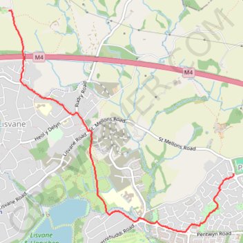
Walk Pontprennau to Ty Mawr
- Distance: 2.8 mi
- Elevation gain: 42 m
- Maximum elevation: 138 m
- Elevation loss: 114 m
- Minimum elevation: 28 m
- Moving time: 58 m 42 s
- Moving speed: 2.9 mph
- Maximum speed: 4.8 mph
- Total time: 58 m 42 s
- Global speed: 2.9 mph
Interactive trail map
Trail profile
- Distance: 2.8 mi
- Elevation gain: 42 m
- Maximum elevation: 138 m
- Elevation loss: 114 m
- Minimum elevation: 28 m
- Moving time: 58 m 42 s
- Moving speed: 2.9 mph
- Maximum speed: 4.8 mph
- Total time: 58 m 42 s
- Global speed: 2.9 mph
About this trail
Name: Walk Pontprennau to Ty Mawr trail, distance, elevation, map, profile, GPS track
Start: Graig Road, Lisvane, Cardiff, Wales, CF14 0UF, United Kingdom (51.55109 -3.17871)
End: Heol Glandulais, Pontprennau, Cardiff, Wales, CF23 8LJ, United Kingdom (51.53588 -3.14503)
Coordinates: 51.53040 -3.17871 51.55109 -3.14499
Topography: Cardiff topographic map, elevation, terrain
Other hiking, mountain biking, running and outdoor activity trails
Click on a trail to view its statistics, map and profile.
The Headstock 500
United Kingdom > Wales > Newport > Newport
Distance: 300.4 mi • Elevation gain: 9,616 m • Maximum elevation: 691 m