Make a donation
Gear up for your next adventure:
As an Amazon Associate, this site earns from qualifying purchases at no extra cost to you.
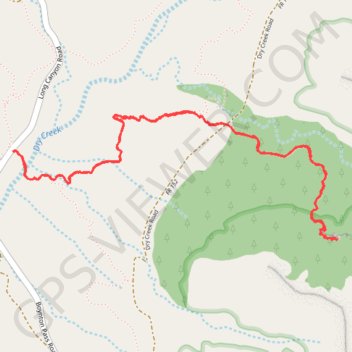
Devil's Bridge from Mescal Trailhead via Chuckwagon Trail and Devil's Bridge Trail in Coconino National Forest
Devil's Bridge Trail offers a scenic desert hike through the iconic red rocks of Sedona. The route is fairly easy until the last section, where a short but steep climb adds a bit of a challenge before reaching the impressive natural arch. The payoff at the top, with expansive views and the chance to stand on the famous Devil's Bridge, makes the effort completely worthwhile. #Hiking #Mountain #Forest #Nature
- Distance: 4.0 mi
- Elevation gain: 163 m
- Maximum elevation: 1,521 m
- Elevation loss: 163 m
- Minimum elevation: 1,363 m
- Moving time: 1 h 53 m
- Moving speed: 2.1 mph
- Maximum speed: 3.1 mph
- Total time: 3 h 48 m
- Global speed: 1.1 mph
Interactive trail map
Make a donation
Gear up for your next adventure:
As an Amazon Associate, this site earns from qualifying purchases at no extra cost to you.
Trail profile
- Distance: 4.0 mi
- Elevation gain: 163 m
- Maximum elevation: 1,521 m
- Elevation loss: 163 m
- Minimum elevation: 1,363 m
- Moving time: 1 h 53 m
- Moving speed: 2.1 mph
- Maximum speed: 3.1 mph
- Total time: 3 h 48 m
- Global speed: 1.1 mph
Make a donation
Gear up for your next adventure:
As an Amazon Associate, this site earns from qualifying purchases at no extra cost to you.
About this trail
Name: Devil's Bridge from Mescal Trailhead via Chuckwagon Trail and Devil's Bridge Trail in Coconino National Forest trail, distance, elevation, map, profile, GPS track
Start: Long Canyon Road, Yavapai County, Arizona, United States (34.90179 -111.82677)
End: Mescal Trail, Yavapai County, Arizona, United States (34.90177 -111.82665)
Coordinates: 34.89741 -111.82680 34.90368 -111.80752
Make a donation
Gear up for your next adventure:
As an Amazon Associate, this site earns from qualifying purchases at no extra cost to you.
Other hiking, mountain biking, running and outdoor activity trails
Click on a trail to view its statistics, map and profile.
Dry Creek Road to Devil's Bridge in Coconino National Forest
United States > Arizona > Yavapai County > Sedona
This is a popular hike offering a beautiful payoff at the top with views of Sedona's iconic red rock formations. Though the trail starts off easy, it gradually becomes more challenging with a steep, rocky climb toward the sandstone arch, making sturdy footwear a must. Despite the crowds, the experience is well…
Distance: 3.9 mi • Elevation gain: 159 m • Maximum elevation: 1,520 m