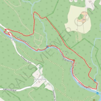
Hemlock Gorge
- Distance: 2.1 mi
- Elevation gain: 75 m
- Maximum elevation: 214 m
- Elevation loss: 75 m
- Minimum elevation: 165 m
- Moving time: 1 h 9 m
- Moving speed: 1.8 mph
- Maximum speed: 9.8 mph
- Total time: 1 h 22 m
- Global speed: 1.5 mph
Interactive trail map
Trail profile
- Distance: 2.1 mi
- Elevation gain: 75 m
- Maximum elevation: 214 m
- Elevation loss: 75 m
- Minimum elevation: 165 m
- Moving time: 1 h 9 m
- Moving speed: 1.8 mph
- Maximum speed: 9.8 mph
- Total time: 1 h 22 m
- Global speed: 1.5 mph
About this trail
Name: Hemlock Gorge trail, distance, elevation, map, profile, GPS track
Start: Gunpowder Road, Walkers Run, Baltimore County, Maryland, 21102, United States (39.69006 -76.78131)
End: Gunpowder Road, Walkers Run, Baltimore County, Maryland, 21102, United States (39.69006 -76.78135)
Coordinates: 39.68427 -76.78150 39.69174 -76.76979