Thank you for supporting this site ❤️
Make a donation
Make a donation
Gear up for your next adventure:
As an Amazon Associate, this site earns from qualifying purchases at no extra cost to you.
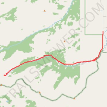
Yarrow Creek trail hike
- Distance: 17.1 mi
- Elevation gain: 834 m
- Maximum elevation: 2,047 m
- Elevation loss: 834 m
- Minimum elevation: 1,472 m
- Moving time: 6 h 56 m
- Moving speed: 2.5 mph
- Maximum speed: 36.1 mph
- Total time: 9 h 32 m
- Global speed: 1.8 mph
Interactive trail map
Thank you for supporting this site ❤️
Make a donation
Make a donation
Gear up for your next adventure:
As an Amazon Associate, this site earns from qualifying purchases at no extra cost to you.
Trail profile
- Distance: 17.1 mi
- Elevation gain: 834 m
- Maximum elevation: 2,047 m
- Elevation loss: 834 m
- Minimum elevation: 1,472 m
- Moving time: 6 h 56 m
- Moving speed: 2.5 mph
- Maximum speed: 36.1 mph
- Total time: 9 h 32 m
- Global speed: 1.8 mph
Thank you for supporting this site ❤️
Make a donation
Make a donation
Gear up for your next adventure:
As an Amazon Associate, this site earns from qualifying purchases at no extra cost to you.
About this trail
Name: Yarrow Creek trail hike trail, distance, elevation, map, profile, GPS track
Start: Yarrow Ridge Route, Municipal District of Pincher Creek No. 9, Alberta, Canada (49.22075 -113.97106)
End: Yarrow Ridge Route, Municipal District of Pincher Creek No. 9, Alberta, Canada (49.22071 -113.97095)
Coordinates: 49.18415 -114.09519 49.22076 -113.97092
Thank you for supporting this site ❤️
Make a donation
Make a donation
Gear up for your next adventure:
As an Amazon Associate, this site earns from qualifying purchases at no extra cost to you.