Make a donation
Gear up for your next adventure:
As an Amazon Associate, this site earns from qualifying purchases at no extra cost to you.
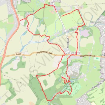
Penn Common and Baggeridge Country Park
Paths around Penn and Baggeridge
- Distance: 6.6 mi
- Elevation gain: 209 m
- Maximum elevation: 180 m
- Elevation loss: 205 m
- Minimum elevation: 116 m
- Moving time: 2 h 39 m
- Moving speed: 2.5 mph
- Maximum speed: 5.4 mph
- Total time: 3 h 28 m
- Global speed: 1.9 mph
Interactive trail map
Make a donation
Gear up for your next adventure:
As an Amazon Associate, this site earns from qualifying purchases at no extra cost to you.
Trail profile
- Distance: 6.6 mi
- Elevation gain: 209 m
- Maximum elevation: 180 m
- Elevation loss: 205 m
- Minimum elevation: 116 m
- Moving time: 2 h 39 m
- Moving speed: 2.5 mph
- Maximum speed: 5.4 mph
- Total time: 3 h 28 m
- Global speed: 1.9 mph
Make a donation
Gear up for your next adventure:
As an Amazon Associate, this site earns from qualifying purchases at no extra cost to you.
About this trail
Name: Penn Common and Baggeridge Country Park trail, distance, elevation, map, profile, GPS track
Coordinates: 52.52921 -2.16946 52.55333 -2.14303
Topography: South Staffordshire topographic map, elevation, terrain
Make a donation
Gear up for your next adventure:
As an Amazon Associate, this site earns from qualifying purchases at no extra cost to you.
Other hiking, mountain biking, running and outdoor activity trails
Click on a trail to view its statistics, map and profile.
Upper Penn Loop Walk
United Kingdom > England > Staffordshire > South Staffordshire > Gospel End
Distance: 6.6 mi • Elevation gain: 197 m • Maximum elevation: 180 m