Thank you for supporting this site ❤️
Make a donation
Make a donation
Gear up for your next adventure:
As an Amazon Associate, this site earns from qualifying purchases at no extra cost to you.
Hemlock DH
- Distance: 12.8 mi
- Elevation gain: 670 m
- Maximum elevation: 540 m
- Elevation loss: 672 m
- Minimum elevation: 264 m
Interactive trail map
Thank you for supporting this site ❤️
Make a donation
Make a donation
Gear up for your next adventure:
As an Amazon Associate, this site earns from qualifying purchases at no extra cost to you.
Trail profile
- Distance: 12.8 mi
- Elevation gain: 670 m
- Maximum elevation: 540 m
- Elevation loss: 672 m
- Minimum elevation: 264 m
Thank you for supporting this site ❤️
Make a donation
Make a donation
Gear up for your next adventure:
As an Amazon Associate, this site earns from qualifying purchases at no extra cost to you.
About this trail
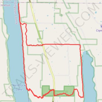
Name: Hemlock DH trail, distance, elevation, map, profile, GPS track
End: Town of Canadice, Ontario County, New York, 14466, United States (42.76257 -77.61101)
Coordinates: 42.72023 -77.61126 42.76257 -77.57162
Thank you for supporting this site ❤️
Make a donation
Make a donation
Gear up for your next adventure:
As an Amazon Associate, this site earns from qualifying purchases at no extra cost to you.