Make a donation
Gear up for your next adventure:
As an Amazon Associate, this site earns from qualifying purchases at no extra cost to you.
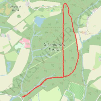
Loop Walk - St Leonards Forest
- Distance: 3.5 mi
- Elevation gain: 87 m
- Maximum elevation: 130 m
- Elevation loss: 87 m
- Minimum elevation: 72 m
- Moving time: 1 h 1 m
- Moving speed: 3.4 mph
- Maximum speed: 5.9 mph
- Total time: 1 h 12 m
- Global speed: 2.9 mph
Interactive trail map
Make a donation
Gear up for your next adventure:
As an Amazon Associate, this site earns from qualifying purchases at no extra cost to you.
Trail profile
- Distance: 3.5 mi
- Elevation gain: 87 m
- Maximum elevation: 130 m
- Elevation loss: 87 m
- Minimum elevation: 72 m
- Moving time: 1 h 1 m
- Moving speed: 3.4 mph
- Maximum speed: 5.9 mph
- Total time: 1 h 12 m
- Global speed: 2.9 mph
Make a donation
Gear up for your next adventure:
As an Amazon Associate, this site earns from qualifying purchases at no extra cost to you.
About this trail
Name: Loop Walk - St Leonards Forest trail, distance, elevation, map, profile, GPS track
Coordinates: 51.05498 -0.27762 51.07336 -0.26004
Topography: West Sussex topographic map, elevation, terrain
Make a donation
Gear up for your next adventure:
As an Amazon Associate, this site earns from qualifying purchases at no extra cost to you.
Other hiking, mountain biking, running and outdoor activity trails
Click on a trail to view its statistics, map and profile.
Walk - Slaugham, Furnace Pond, Lower Beeding
United Kingdom > England > West Sussex > Horsham
Distance: 10.7 mi • Elevation gain: 292 m • Maximum elevation: 127 m
Walk - Slaugham, Furnace Pond, Lower Beeding
United Kingdom > England > West Sussex > Mid Sussex > Slaugham
Distance: 10.7 mi • Elevation gain: 296 m • Maximum elevation: 127 m
Walk - Furnace Pond, Lower Beeding
United Kingdom > England > West Sussex > Mid Sussex > Slaugham
Distance: 11.0 mi • Elevation gain: 302 m • Maximum elevation: 126 m