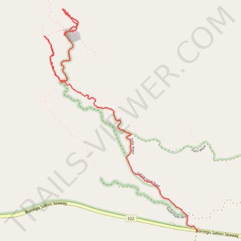
Calcite Mine Slot
- Distance: 3.4 mi
- Elevation gain: 152 m
- Maximum elevation: 387 m
- Elevation loss: 310 m
- Minimum elevation: 164 m
- Moving time: 1 h 20 m
- Moving speed: 2.5 mph
- Maximum speed: 11.1 mph
- Total time: 1 h 24 m
- Global speed: 2.4 mph
Interactive trail map
Trail profile
- Distance: 3.4 mi
- Elevation gain: 152 m
- Maximum elevation: 387 m
- Elevation loss: 310 m
- Minimum elevation: 164 m
- Moving time: 1 h 20 m
- Moving speed: 2.5 mph
- Maximum speed: 11.1 mph
- Total time: 1 h 24 m
- Global speed: 2.4 mph
About this trail
Name: Calcite Mine Slot trail, distance, elevation, map, profile, GPS track
Start: Calcite Mine Road, San Diego County, California, United States (33.29857 -116.11062)
End: Truckhaven Trail, San Diego County, California, United States (33.28086 -116.09635)
Coordinates: 33.28086 -116.11278 33.30088 -116.09631