Thank you for supporting this site ❤️
Make a donation
Make a donation
Gear up for your next adventure:
As an Amazon Associate, this site earns from qualifying purchases at no extra cost to you.
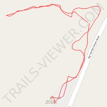
Big Tujunga Dam Overlook
- Distance: 0.4 mi
- Elevation gain: 71 m
- Maximum elevation: 833 m
- Elevation loss: 70 m
- Minimum elevation: 778 m
- Moving time: 14 m 19 s
- Moving speed: 1.7 mph
- Maximum speed: 4.0 mph
- Total time: 25 m 39 s
- Global speed: 0.9 mph
Interactive trail map
Thank you for supporting this site ❤️
Make a donation
Make a donation
Gear up for your next adventure:
As an Amazon Associate, this site earns from qualifying purchases at no extra cost to you.
Trail profile
- Distance: 0.4 mi
- Elevation gain: 71 m
- Maximum elevation: 833 m
- Elevation loss: 70 m
- Minimum elevation: 778 m
- Moving time: 14 m 19 s
- Moving speed: 1.7 mph
- Maximum speed: 4.0 mph
- Total time: 25 m 39 s
- Global speed: 0.9 mph
Thank you for supporting this site ❤️
Make a donation
Make a donation
Gear up for your next adventure:
As an Amazon Associate, this site earns from qualifying purchases at no extra cost to you.
About this trail
Name: Big Tujunga Dam Overlook trail, distance, elevation, map, profile, GPS track
Start: Big Tujunga Canyon Road, Los Angeles County, California, United States (34.29528 -118.17988)
End: Big Tujunga Canyon Road, Los Angeles County, California, United States (34.29527 -118.17986)
Coordinates: 34.29423 -118.18117 34.29552 -118.17968
Thank you for supporting this site ❤️
Make a donation
Make a donation
Gear up for your next adventure:
As an Amazon Associate, this site earns from qualifying purchases at no extra cost to you.