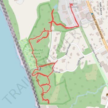
Crawbuckie Nature Preserve Trails
- Distance: 2.2 mi
- Elevation gain: 93 m
- Maximum elevation: 52 m
- Elevation loss: 94 m
- Minimum elevation: 7 m
- Moving time: 49 m
- Moving speed: 2.7 mph
- Maximum speed: 5.3 mph
- Total time: 1 h 8 m
- Global speed: 1.9 mph
Interactive trail map
Trail profile
- Distance: 2.2 mi
- Elevation gain: 93 m
- Maximum elevation: 52 m
- Elevation loss: 94 m
- Minimum elevation: 7 m
- Moving time: 49 m
- Moving speed: 2.7 mph
- Maximum speed: 5.3 mph
- Total time: 1 h 8 m
- Global speed: 1.9 mph
About this trail
Name: Crawbuckie Nature Preserve Trails trail, distance, elevation, map, profile, GPS track
Coordinates: 41.16732 -73.87224 41.17421 -73.86771
Other hiking, mountain biking, running and outdoor activity trails
Click on a trail to view its statistics, map and profile.
Old Croton Aqueduct Trail and Bronx
United States > New York > Westchester County > Village of Croton-on-Hudson
Distance: 44.0 mi • Elevation gain: 823 m • Maximum elevation: 80 m