Make a donation
Gear up for your next adventure:
As an Amazon Associate, this site earns from qualifying purchases at no extra cost to you.
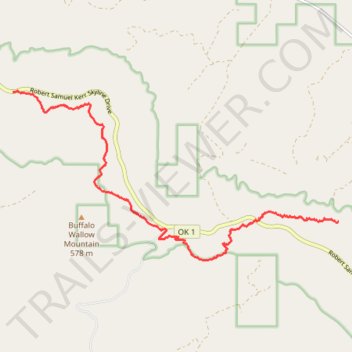
Ouachita National Recreation Trail from Potato Hill Vista to Rock Garden Shelter
- Distance: 7.0 mi
- Elevation gain: 238 m
- Maximum elevation: 667 m
- Elevation loss: 398 m
- Minimum elevation: 399 m
- Moving time: 2 h 59 m
- Moving speed: 2.4 mph
- Maximum speed: 3.6 mph
- Total time: 3 h 16 m
- Global speed: 2.2 mph
Interactive trail map
Make a donation
Gear up for your next adventure:
As an Amazon Associate, this site earns from qualifying purchases at no extra cost to you.
Trail profile
- Distance: 7.0 mi
- Elevation gain: 238 m
- Maximum elevation: 667 m
- Elevation loss: 398 m
- Minimum elevation: 399 m
- Moving time: 2 h 59 m
- Moving speed: 2.4 mph
- Maximum speed: 3.6 mph
- Total time: 3 h 16 m
- Global speed: 2.2 mph
Make a donation
Gear up for your next adventure:
As an Amazon Associate, this site earns from qualifying purchases at no extra cost to you.
About this trail
Name: Ouachita National Recreation Trail from Potato Hill Vista to Rock Garden Shelter trail, distance, elevation, map, profile, GPS track
Start: Robert Samuel Kerr Skyline Drive, LeFlore County, Oklahoma, United States (34.79528 -94.92550)
End: Ouachita National Recreation Trail, LeFlore County, Oklahoma, United States (34.77188 -94.85413)
Coordinates: 34.76503 -94.92550 34.79545 -94.85413
Make a donation
Gear up for your next adventure:
As an Amazon Associate, this site earns from qualifying purchases at no extra cost to you.