Make a donation
Gear up for your next adventure:
As an Amazon Associate, this site earns from qualifying purchases at no extra cost to you.
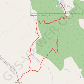
Milenkov Kamen (Karadzica)
- Distance: 6.5 mi
- Elevation gain: 1,024 m
- Maximum elevation: 2,200 m
- Elevation loss: 1,282 m
- Minimum elevation: 958 m
- Moving time: 5 h 42 m
- Moving speed: 1.1 mph
- Maximum speed: 14.7 mph
- Total time: 6 h 50 m
- Global speed: 0.9 mph
Interactive trail map
Make a donation
Gear up for your next adventure:
As an Amazon Associate, this site earns from qualifying purchases at no extra cost to you.
Trail profile
- Distance: 6.5 mi
- Elevation gain: 1,024 m
- Maximum elevation: 2,200 m
- Elevation loss: 1,282 m
- Minimum elevation: 958 m
- Moving time: 5 h 42 m
- Moving speed: 1.1 mph
- Maximum speed: 14.7 mph
- Total time: 6 h 50 m
- Global speed: 0.9 mph
Make a donation
Gear up for your next adventure:
As an Amazon Associate, this site earns from qualifying purchases at no extra cost to you.
About this trail
Name: Milenkov Kamen (Karadzica) trail, distance, elevation, map, profile, GPS track
Start: Patishka Reka, Municipality of Sopishte, North Macedonia (41.78641 21.31441)
End: Patiška Reka, Patishka Reka, Municipality of Sopishte, North Macedonia (41.80052 21.31578)
Coordinates: 41.76872 21.29247 41.80052 21.31931
Make a donation
Gear up for your next adventure:
As an Amazon Associate, this site earns from qualifying purchases at no extra cost to you.
Other hiking, mountain biking, running and outdoor activity trails
Click on a trail to view its statistics, map and profile.
Patiška Reka-Milenkov kamen-Mirska voda-Patiska reka
North Macedonia > Patishka Reka
Distance: 9.1 mi • Elevation gain: 1,342 m • Maximum elevation: 2,202 m