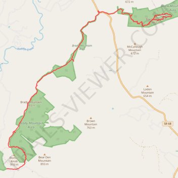
CT - Brady Mountain & Black Mountain
- Distance: 14.7 mi
- Elevation gain: 836 m
- Maximum elevation: 887 m
- Elevation loss: 702 m
- Minimum elevation: 533 m
- Moving time: 6 h 6 m
- Moving speed: 2.4 mph
- Maximum speed: 3.8 mph
- Total time: 22 h 21 m
- Global speed: 0.7 mph
Interactive trail map
Trail profile
- Distance: 14.7 mi
- Elevation gain: 836 m
- Maximum elevation: 887 m
- Elevation loss: 702 m
- Minimum elevation: 533 m
- Moving time: 6 h 6 m
- Moving speed: 2.4 mph
- Maximum speed: 3.8 mph
- Total time: 22 h 21 m
- Global speed: 0.7 mph
About this trail
Name: CT - Brady Mountain & Black Mountain trail, distance, elevation, map, profile, GPS track
Start: Hinch Road, Cumberland County, East Tennessee, Tennessee, 38555, United States (35.79204 -84.98562)
End: Grassy Cove Trail, Cumberland County, East Tennessee, Tennessee, United States (35.86419 -84.89824)
Coordinates: 35.79179 -84.98562 35.87140 -84.88474
Other hiking, mountain biking, running and outdoor activity trails
Click on a trail to view its statistics, map and profile.
Cumberland Trail, Head of the Sequatchie River and Devilstep Cave
United States > Tennessee > Cumberland County
Distance: 7.4 mi • Elevation gain: 579 m • Maximum elevation: 686 m
Cumberland Trail from Head of Sequatchie to Stinging Fork via Hinch Mountain
United States > Tennessee > Cumberland County
Distance: 17.5 mi • Elevation gain: 1,110 m • Maximum elevation: 765 m