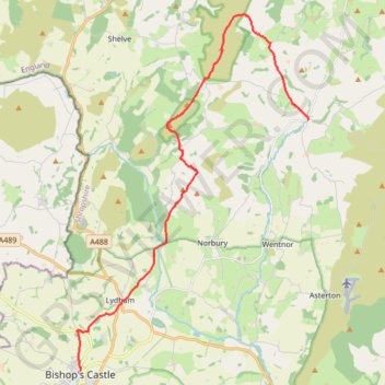
Bridges to Bishops Castle
- Distance: 11.7 mi
- Elevation gain: 548 m
- Maximum elevation: 527 m
- Elevation loss: 588 m
- Minimum elevation: 169 m
- Moving time: 5 h 22 m
- Moving speed: 2.2 mph
- Maximum speed: 3.4 mph
- Total time: 7 h 8 m
- Global speed: 1.6 mph
Interactive trail map
Trail profile
- Distance: 11.7 mi
- Elevation gain: 548 m
- Maximum elevation: 527 m
- Elevation loss: 588 m
- Minimum elevation: 169 m
- Moving time: 5 h 22 m
- Moving speed: 2.2 mph
- Maximum speed: 3.4 mph
- Total time: 7 h 8 m
- Global speed: 1.6 mph
About this trail
Name: Bridges to Bishops Castle trail, distance, elevation, map, profile, GPS track
Start: Bridges, Ratlinghope, Shropshire, England, SY5 0ST, United Kingdom (52.56254 -2.89652)
End: High Street, Bishop's Castle, Shropshire, England, SY9 5BN, United Kingdom (52.49462 -2.99763)
Coordinates: 52.49462 -2.99917 52.59105 -2.89615
Topography: Shropshire topographic map, elevation, terrain
Other hiking, mountain biking, running and outdoor activity trails
Click on a trail to view its statistics, map and profile.
Church Stretton to Bridges
United Kingdom > England > Shropshire > Church Stretton
Distance: 9.5 mi • Elevation gain: 410 m • Maximum elevation: 512 m
RE SO320930
United Kingdom > England > Shropshire > Lydham > Owlbury
Distance: 1.8 mi • Elevation gain: 113 m • Maximum elevation: 231 m