Import a GPX file

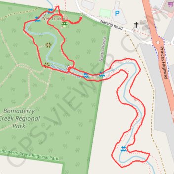
Bomaderry Creek Walk

#Hiking #Loop #Bomaderry

  • Distance: 2.0 mi
  • Elevation gain: 44 m
  • Maximum elevation: 44 m
  • Elevation loss: 44 m
  • Minimum elevation: 24 m

Interactive trail map

Trail profile

  • Distance: 2.0 mi
  • Elevation gain: 44 m
  • Maximum elevation: 44 m
  • Elevation loss: 44 m
  • Minimum elevation: 24 m

About this trail

Other hiking, mountain biking, running and outdoor activity trails

Click on a trail to view its statistics, map and profile.

Ulladulla - Minnamurra

Australia > New South Wales > Burrill Lake

#Bike

Distance: 79.4 mi • Elevation gain: 1,627 m • Maximum elevation: 143 m

Shell Cove - Duffy

Australia > New South Wales

#Bike #Canberra

Distance: 181.6 mi • Elevation gain: 3,534 m • Maximum elevation: 872 m

Gear up for your next adventure:

🧼Technical Clothing Wash - Special soap to clean and restore waterproof membranes
🧼Biodegradable Soap - Leave-no-trace hygiene for multi-day mountain treks
🌦️Portable Weather Meters - Handheld tools for monitoring weather conditions
🧭Emergency Beacons - Safety beacons for remote outdoor locations
🔪Outdoor Multi-Tools - Versatile tools for gear repairs and food prep in the wild

As an Amazon Associate, this site earns from qualifying purchases at no extra cost to you.