Thank you for supporting this site ❤️
Make a donation
Make a donation
Gear up for your next adventure:
As an Amazon Associate, this site earns from qualifying purchases at no extra cost to you.
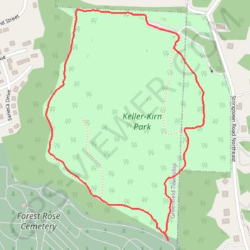
Keller Kirn outer loop trail (with entrance from cemetery)
- Distance: 1.3 mi
- Elevation gain: 50 m
- Maximum elevation: 348 m
- Elevation loss: 50 m
- Minimum elevation: 306 m
- Moving time: 24 m 19 s
- Moving speed: 3.3 mph
- Maximum speed: 9.9 mph
- Total time: 24 m 54 s
- Global speed: 3.2 mph
Interactive trail map
Thank you for supporting this site ❤️
Make a donation
Make a donation
Gear up for your next adventure:
As an Amazon Associate, this site earns from qualifying purchases at no extra cost to you.
Trail profile
- Distance: 1.3 mi
- Elevation gain: 50 m
- Maximum elevation: 348 m
- Elevation loss: 50 m
- Minimum elevation: 306 m
- Moving time: 24 m 19 s
- Moving speed: 3.3 mph
- Maximum speed: 9.9 mph
- Total time: 24 m 54 s
- Global speed: 3.2 mph
Thank you for supporting this site ❤️
Make a donation
Make a donation
Gear up for your next adventure:
As an Amazon Associate, this site earns from qualifying purchases at no extra cost to you.
About this trail
Name: Keller Kirn outer loop trail (with entrance from cemetery) trail, distance, elevation, map, profile, GPS track
Coordinates: 39.73211 -82.60479 39.73874 -82.59889
Thank you for supporting this site ❤️
Make a donation
Make a donation
Gear up for your next adventure:
As an Amazon Associate, this site earns from qualifying purchases at no extra cost to you.
Other hiking, mountain biking, running and outdoor activity trails
Click on a trail to view its statistics, map and profile.
Keller-Kirn Park
United States > Ohio > Fairfield County > Lancaster
Distance: 1.1 mi • Elevation gain: 46 m • Maximum elevation: 345 m