Thank you for supporting this site ❤️
Make a donation
Make a donation
Gear up for your next adventure:
As an Amazon Associate, this site earns from qualifying purchases at no extra cost to you.
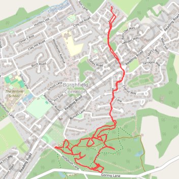
West Berkshire Walking
- Distance: 3.2 mi
- Elevation gain: 25 m
- Maximum elevation: 97 m
- Elevation loss: 22 m
- Minimum elevation: 81 m
- Moving time: 1 h 20 m
- Moving speed: 2.4 mph
- Maximum speed: 5.3 mph
- Total time: 1 h 28 m
- Global speed: 2.2 mph
Interactive trail map
Thank you for supporting this site ❤️
Make a donation
Make a donation
Gear up for your next adventure:
As an Amazon Associate, this site earns from qualifying purchases at no extra cost to you.
Trail profile
- Distance: 3.2 mi
- Elevation gain: 25 m
- Maximum elevation: 97 m
- Elevation loss: 22 m
- Minimum elevation: 81 m
- Moving time: 1 h 20 m
- Moving speed: 2.4 mph
- Maximum speed: 5.3 mph
- Total time: 1 h 28 m
- Global speed: 2.2 mph
Thank you for supporting this site ❤️
Make a donation
Make a donation
Gear up for your next adventure:
As an Amazon Associate, this site earns from qualifying purchases at no extra cost to you.
About this trail
Name: West Berkshire Walking trail, distance, elevation, map, profile, GPS track
Coordinates: 51.39111 -1.06482 51.40307 -1.05676
Topography: West Berkshire topographic map, elevation, terrain
Thank you for supporting this site ❤️
Make a donation
Make a donation
Gear up for your next adventure:
As an Amazon Associate, this site earns from qualifying purchases at no extra cost to you.