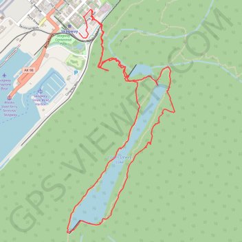
Lower Dewey Lake Loop Hike in Skagway Alaska USA
- Distance: 3.8 mi
- Elevation gain: 377 m
- Maximum elevation: 243 m
- Elevation loss: 376 m
- Minimum elevation: 10 m
- Moving time: 1 h 55 m
- Moving speed: 2.0 mph
- Maximum speed: 13.4 mph
- Total time: 2 h 2 m
- Global speed: 1.9 mph
Interactive trail map
Trail profile
- Distance: 3.8 mi
- Elevation gain: 377 m
- Maximum elevation: 243 m
- Elevation loss: 376 m
- Minimum elevation: 10 m
- Moving time: 1 h 55 m
- Moving speed: 2.0 mph
- Maximum speed: 13.4 mph
- Total time: 2 h 2 m
- Global speed: 1.9 mph
About this trail
Name: Lower Dewey Lake Loop Hike in Skagway Alaska USA trail, distance, elevation, map, profile, GPS track
Start: 2nd Avenue, Skagway, Alaska, 99840, United States (59.45285 -135.31682)
End: 268, 4th Avenue, Skagway, Alaska, 99840, United States (59.45430 -135.31527)
Coordinates: 59.44025 -135.31834 59.45435 -135.30499