Thank you for supporting this site ❤️
Make a donation
Make a donation
Gear up for your next adventure:
As an Amazon Associate, this site earns from qualifying purchases at no extra cost to you.
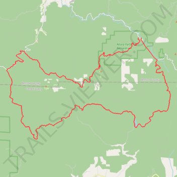
Gravel road around Alsea Falls
- Distance: 43.8 mi
- Elevation gain: 2,460 m
- Maximum elevation: 903 m
- Elevation loss: 2,463 m
- Minimum elevation: 104 m
- Moving time: 5 h 16 m
- Moving speed: 8.3 mph
- Maximum speed: 35.6 mph
- Total time: 5 h 56 m
- Global speed: 7.4 mph
Interactive trail map
Thank you for supporting this site ❤️
Make a donation
Make a donation
Gear up for your next adventure:
As an Amazon Associate, this site earns from qualifying purchases at no extra cost to you.
Trail profile
- Distance: 43.8 mi
- Elevation gain: 2,460 m
- Maximum elevation: 903 m
- Elevation loss: 2,463 m
- Minimum elevation: 104 m
- Moving time: 5 h 16 m
- Moving speed: 8.3 mph
- Maximum speed: 35.6 mph
- Total time: 5 h 56 m
- Global speed: 7.4 mph
Thank you for supporting this site ❤️
Make a donation
Make a donation
Gear up for your next adventure:
As an Amazon Associate, this site earns from qualifying purchases at no extra cost to you.
About this trail
Name: Gravel road around Alsea Falls trail, distance, elevation, map, profile, GPS track
Start: Fall Creek Access Road, Benton County, Oregon, United States (44.32161 -123.49035)
End: Alsea Falls Campground Road, Benton County, Oregon, United States (44.32130 -123.48711)
Coordinates: 44.22901 -123.65902 44.32161 -123.44991
Thank you for supporting this site ❤️
Make a donation
Make a donation
Gear up for your next adventure:
As an Amazon Associate, this site earns from qualifying purchases at no extra cost to you.