Make a donation
Gear up for your next adventure:
As an Amazon Associate, this site earns from qualifying purchases at no extra cost to you.
New
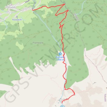
- Distance: 3.9 mi
- Elevation gain: 1,133 m
- Maximum elevation: 2,338 m
- Elevation loss: 12 m
- Minimum elevation: 1,215 m
Interactive trail map
Make a donation
Gear up for your next adventure:
As an Amazon Associate, this site earns from qualifying purchases at no extra cost to you.
Trail profile
- Distance: 3.9 mi
- Elevation gain: 1,133 m
- Maximum elevation: 2,338 m
- Elevation loss: 12 m
- Minimum elevation: 1,215 m
Make a donation
Gear up for your next adventure:
As an Amazon Associate, this site earns from qualifying purchases at no extra cost to you.
About this trail
Name: New trail, distance, elevation, map, profile, GPS track
Start: 116, Bachegg, Tobadill, Bezirk Landeck, Tyrol, 6552, Austria (47.12502 10.52227)
End: Zirmegg, Tobadill, Bezirk Landeck, Tyrol, 6552, Austria (47.09973 10.53427)
Coordinates: 47.09973 10.52227 47.12665 10.53923
Make a donation
Gear up for your next adventure:
As an Amazon Associate, this site earns from qualifying purchases at no extra cost to you.
Other hiking, mountain biking, running and outdoor activity trails
Click on a trail to view its statistics, map and profile.
Riethoven naar Oostenrijk
Netherlands > North Brabant > Riethoven > Eind
Distance: 573.0 mi • Elevation gain: 13,629 m • Maximum elevation: 1,897 m