Thank you for supporting this site ❤️
Make a donation
Make a donation
Gear up for your next adventure:
As an Amazon Associate, this site earns from qualifying purchases at no extra cost to you.
2023-04-22 06:42:18
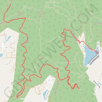
- Distance: 7.4 mi
- Elevation gain: 674 m
- Maximum elevation: 266 m
- Elevation loss: 578 m
- Minimum elevation: 47 m
- Moving time: 2 h 34 m
- Moving speed: 2.9 mph
- Maximum speed: 13.9 mph
- Total time: 2 h 38 m
- Global speed: 2.8 mph
Interactive trail map
Thank you for supporting this site ❤️
Make a donation
Make a donation
Gear up for your next adventure:
As an Amazon Associate, this site earns from qualifying purchases at no extra cost to you.
Trail profile
- Distance: 7.4 mi
- Elevation gain: 674 m
- Maximum elevation: 266 m
- Elevation loss: 578 m
- Minimum elevation: 47 m
- Moving time: 2 h 34 m
- Moving speed: 2.9 mph
- Maximum speed: 13.9 mph
- Total time: 2 h 38 m
- Global speed: 2.8 mph
Thank you for supporting this site ❤️
Make a donation
Make a donation
Gear up for your next adventure:
As an Amazon Associate, this site earns from qualifying purchases at no extra cost to you.
About this trail
Name: 2023-04-22 06:42:18 trail, distance, elevation, map, profile, GPS track
Start: Xã Nam Sơn, Sóc Sơn District, Hà Nội, Vietnam (21.30384 105.80347)
End: Ham Lon Fire Trail, Xã Minh Trí, Sóc Sơn District, Hà Nội, Vietnam (21.31573 105.78100)
Coordinates: 21.29325 105.77919 21.31573 105.80347
Thank you for supporting this site ❤️
Make a donation
Make a donation
Gear up for your next adventure:
As an Amazon Associate, this site earns from qualifying purchases at no extra cost to you.