Thank you for supporting this site ❤️
Make a donation
Make a donation
Gear up for your next adventure:
As an Amazon Associate, this site earns from qualifying purchases at no extra cost to you.
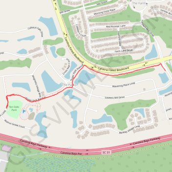
Black Creek to Ten Oaks Park
- Distance: 1.1 mi
- Elevation gain: 4 m
- Maximum elevation: 8 m
- Elevation loss: 4 m
- Minimum elevation: 6 m
- Moving time: 32 m 51 s
- Moving speed: 2.0 mph
- Maximum speed: 5.9 mph
- Total time: 34 m 21 s
- Global speed: 1.9 mph
Interactive trail map
Thank you for supporting this site ❤️
Make a donation
Make a donation
Gear up for your next adventure:
As an Amazon Associate, this site earns from qualifying purchases at no extra cost to you.
Trail profile
- Distance: 1.1 mi
- Elevation gain: 4 m
- Maximum elevation: 8 m
- Elevation loss: 4 m
- Minimum elevation: 6 m
- Moving time: 32 m 51 s
- Moving speed: 2.0 mph
- Maximum speed: 5.9 mph
- Total time: 34 m 21 s
- Global speed: 1.9 mph
Thank you for supporting this site ❤️
Make a donation
Make a donation
Gear up for your next adventure:
As an Amazon Associate, this site earns from qualifying purchases at no extra cost to you.
About this trail
Name: Black Creek to Ten Oaks Park trail, distance, elevation, map, profile, GPS track
Coordinates: 33.75161 -78.88806 33.75469 -78.87496
Thank you for supporting this site ❤️
Make a donation
Make a donation
Gear up for your next adventure:
As an Amazon Associate, this site earns from qualifying purchases at no extra cost to you.