Calico Tanks
Interactive trail map
Trail profile
- Distance: 1.1 mi
- Elevation gain: 134 m
- Maximum elevation: 1,448 m
- Elevation loss: 13 m
- Minimum elevation: 1,318 m
About this trail
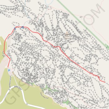
Name: Calico Tanks trail, distance, elevation, map, profile, GPS track
Start: Calico Tanks Trail, Clark County, Nevada, United States (36.16246 -115.45035)
End: Calico Tanks Trail, Clark County, Nevada, United States (36.16092 -115.43793)
Coordinates: 36.16092 -115.45085 36.16664 -115.43793
Other hiking, mountain biking, running and outdoor activity trails
Click on a trail to view its statistics, map and profile.
Turtlehead Peak Trail in Red Rock Canyon National Conservation Area
United States > Nevada > Clark County
Turtlehead Peak Trail offers a fantastic blend of natural beauty and a bit of a workout. The hike takes you past ancient petroglyphs and up to a ridge with amazing views of Las Vegas and the stunning sandstone formations around you. While the trail can be rocky and steep in sections, the sense of…
Distance: 4.7 mi • Elevation gain: 612 m • Maximum elevation: 1,898 m
Calico Tanks Trail in Red Rock Canyon National Conservation Area
United States > Nevada > Clark County
The Calico Tanks Trail is a fantastic way to immerse yourself in the beauty of nature while enjoying some stunning views of the Las Vegas skyline. The trail is well-marked and provides a great workout, making it easy to explore the unique sandstone formations along the way. Starting early is a smart choice, as…
Distance: 2.5 mi • Elevation gain: 143 m • Maximum elevation: 1,448 m