Visit of Fort William
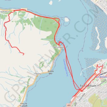
Walk in the city center, ferry to Camusnagaul and hike to Treslaig Tower Viewpoint. #Hiking #Walking #City #Boat #Sea #Nature #Mountain #Forest #Highlands
- Distance: 9.6 mi
- Elevation gain: 345 m
- Maximum elevation: 284 m
- Elevation loss: 344 m
- Minimum elevation: 0 m
- Moving time: 4 h 3 m
- Moving speed: 2.4 mph
- Maximum speed: 8.8 mph
- Total time: 6 h 15 m
- Global speed: 1.5 mph
Interactive trail map
Trail profile
- Distance: 9.6 mi
- Elevation gain: 345 m
- Maximum elevation: 284 m
- Elevation loss: 344 m
- Minimum elevation: 0 m
- Moving time: 4 h 3 m
- Moving speed: 2.4 mph
- Maximum speed: 8.8 mph
- Total time: 6 h 15 m
- Global speed: 1.5 mph
About this trail
Name: Visit of Fort William trail, distance, elevation, map, profile, GPS track
Start: A82, An Aird, Fort William, Highland, Scotland, PH33 6DN, United Kingdom (56.81586 -5.11620)
Coordinates: 56.81498 -5.14823 56.83624 -5.10441
Topography: Highland topographic map, elevation, terrain
Other hiking, mountain biking, running and outdoor activity trails
Click on a trail to view its statistics, map and profile.
Great Glen Way (Fort William to Fort Augustus)
United Kingdom > Scotland > Highland > Fort William
Distance: 32.7 mi • Elevation gain: 598 m • Maximum elevation: 108 m