
Mina Sauk Falls Loop Trail in Taum Sauk Mountain State Park
The Mina Sauk Falls Loop Trail offers a challenging yet rewarding hike through the rugged terrain of the St. Francois Mountains. As the trail progresses, hikers are treated to panoramic views of rocky outcrops and dense forests, with the highlight being the majestic Mina Sauk Falls, Missouri's tallest waterfall, especially impressive after rain. The trail is diverse, meandering through areas of exposed rock and tranquil streams, before descending to the falls' base where visitors can feel the cool mist of cascading water. #Hiking #Loop #Waterfall #Forest #Nature
- Distance: 3.0 mi
- Elevation gain: 135 m
- Maximum elevation: 539 m
- Elevation loss: 130 m
- Minimum elevation: 410 m
- Moving time: 1 h 20 m
- Moving speed: 2.3 mph
- Maximum speed: 4.5 mph
- Total time: 1 h 47 m
- Global speed: 1.7 mph
Interactive trail map
Trail profile
- Distance: 3.0 mi
- Elevation gain: 135 m
- Maximum elevation: 539 m
- Elevation loss: 130 m
- Minimum elevation: 410 m
- Moving time: 1 h 20 m
- Moving speed: 2.3 mph
- Maximum speed: 4.5 mph
- Total time: 1 h 47 m
- Global speed: 1.7 mph
About this trail
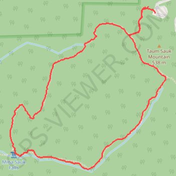
Name: Mina Sauk Falls Loop Trail in Taum Sauk Mountain State Park trail, distance, elevation, map, profile, GPS track
Start: Mina Sauk Falls Trail, Iron County, Missouri, United States (37.57308 -90.72881)
End: Mina Sauk Falls Trail, Iron County, Missouri, United States (37.57261 -90.72820)
Coordinates: 37.56156 -90.74117 37.57308 -90.72724