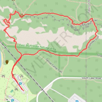
Balanced Rock and Devil's Doorway Loop via Balanced Rock Trail, East Bluff Trail, Devil's Doorway Trail, Potholes Trail and Grottos Trail in Devil's Lake State Park
The Balanced Rock and Devil's Doorway Loop offers a unique blend of breathtaking vistas and challenging terrain, rewarding hikers with views of the lake and surrounding bluffs. The route includes steep stone steps along the Balanced Rock Trail, ascending through dense pine forest to views of Devil's Lake, with Balanced Rock itself precariously perched on the bluff’s edge. After passing Devil’s Doorway, a natural rock formation shaped like an open frame, the Potholes Trail descent offers a rugged, staircase-like path, ending in a flat forested return along the Grottos Trail—a refreshing end to an invigorating loop. #Hiking #Loop #Lake #Forest #Nature
- Distance: 1.4 mi
- Elevation gain: 150 m
- Maximum elevation: 433 m
- Elevation loss: 149 m
- Minimum elevation: 301 m
- Moving time: 57 m 24 s
- Moving speed: 1.5 mph
- Maximum speed: 9.3 mph
- Total time: 1 h 33 m
- Global speed: 0.9 mph
Interactive trail map
Trail profile
- Distance: 1.4 mi
- Elevation gain: 150 m
- Maximum elevation: 433 m
- Elevation loss: 149 m
- Minimum elevation: 301 m
- Moving time: 57 m 24 s
- Moving speed: 1.5 mph
- Maximum speed: 9.3 mph
- Total time: 1 h 33 m
- Global speed: 0.9 mph
About this trail
Name: Balanced Rock and Devil's Doorway Loop via Balanced Rock Trail, East Bluff Trail, Devil's Doorway Trail, Potholes Trail and Grottos Trail in Devil's Lake State Park trail, distance, elevation, map, profile, GPS track
Start: South Lake Road, Town of Baraboo, Sauk County, Wisconsin, United States (43.41055 -89.72395)
End: South Lake Road, Town of Baraboo, Sauk County, Wisconsin, United States (43.41048 -89.72381)
Coordinates: 43.41048 -89.72535 43.41494 -89.71809
Other hiking, mountain biking, running and outdoor activity trails
Click on a trail to view its statistics, map and profile.
Devil's Lake Loop via West Bluff Trail, South Shore, Balanced Rock and Elephant Rock
United States > Wisconsin > Sauk County
The Devil's Lake (or Spirit Lake) Loop in Wisconsin offers a fantastic combination of scenic views, rock formations, and diverse terrain. Starting with a steep climb, the route reveals stunning views of the lake from towering bluffs, framed by rugged quartzite cliffs and tranquil forested paths. Then, the…
Distance: 4.9 mi • Elevation gain: 328 m • Maximum elevation: 441 m
East Bluff Woods Trail and East Bluff Trail Loop via Devil's Door in Devil's Lake State Park
United States > Wisconsin > Sauk County
This loop offers a captivating hiking experience with breathtaking views of the lake and surrounding bluffs. This moderately strenuous route features diverse terrain, including wooded paths and rocky inclines, leading to the iconic Devil's Doorway, a striking rock formation that serves as a fantastic backdrop…
Distance: 2.8 mi • Elevation gain: 171 m • Maximum elevation: 448 m
Devil's Doorway and Balanced Rock Loop via Grottos Trail, East Bluff Trail and Balanced Rock Trail in Devil's Lake State Park
United States > Wisconsin > Sauk County
This loop offers hikers a spectacular journey through some of the most stunning landscapes in Devil's Lake State Park. Along this route, you will encounter dramatic rock formations, including the iconic Devil's Doorway, which provides breathtaking views of the lake and surrounding bluffs, and the Balanced…
Distance: 2.6 mi • Elevation gain: 159 m • Maximum elevation: 434 m
Devil's Lake Loop via West Bluff Trail, South Shore Boardwalk, Balanced Rock, East Bluff Trail and Elephant Rock in Devil's Lake State Park
United States > Wisconsin > Sauk County
The Devil's Lake Loop offers an enchanting hiking experience that highlights the striking beauty of Wisconsin's natural landscape. Along the route, hikers will encounter breathtaking views from the West Bluff Trail, characterized by towering quartzite cliffs and expansive vistas of Devil’s Lake, making it a…
Distance: 4.5 mi • Elevation gain: 312 m • Maximum elevation: 441 m