Make a donation
Gear up for your next adventure:
As an Amazon Associate, this site earns from qualifying purchases at no extra cost to you.
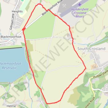
Blackmoorfoot and South Crosland loop
- Distance: 3.1 mi
- Elevation gain: 72 m
- Maximum elevation: 270 m
- Elevation loss: 71 m
- Minimum elevation: 216 m
- Moving time: 1 h 27 m
- Moving speed: 2.1 mph
- Maximum speed: 4.0 mph
- Total time: 1 h 58 m
- Global speed: 1.6 mph
Interactive trail map
Make a donation
Gear up for your next adventure:
As an Amazon Associate, this site earns from qualifying purchases at no extra cost to you.
Trail profile
- Distance: 3.1 mi
- Elevation gain: 72 m
- Maximum elevation: 270 m
- Elevation loss: 71 m
- Minimum elevation: 216 m
- Moving time: 1 h 27 m
- Moving speed: 2.1 mph
- Maximum speed: 4.0 mph
- Total time: 1 h 58 m
- Global speed: 1.6 mph
Make a donation
Gear up for your next adventure:
As an Amazon Associate, this site earns from qualifying purchases at no extra cost to you.
About this trail
Name: Blackmoorfoot and South Crosland loop trail, distance, elevation, map, profile, GPS track
Coordinates: 53.60391 -1.84859 53.62083 -1.83051
Topography: Kirklees topographic map, elevation, terrain
Make a donation
Gear up for your next adventure:
As an Amazon Associate, this site earns from qualifying purchases at no extra cost to you.
Other hiking, mountain biking, running and outdoor activity trails
Click on a trail to view its statistics, map and profile.
Blackmoorfoot reservoir and Crosland Moor
United Kingdom > England > Kirklees > Meltham > Linthwaite > Helme
Distance: 3.2 mi • Elevation gain: 80 m • Maximum elevation: 273 m
Crosland Heath
United Kingdom > England > Kirklees > Linthwaite > Blackmoorfoot
Distance: 1.4 mi • Elevation gain: 46 m • Maximum elevation: 273 m