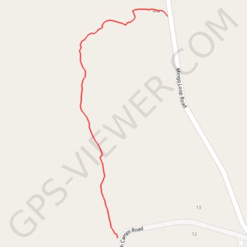
Forest path from North Camps Road to Mingo Loop Road in Rangeley, ME
Forest, path, rangeley, nature
- Distance: 0.4 mi
- Elevation gain: 26 m
- Maximum elevation: 520 m
- Elevation loss: 1 m
- Minimum elevation: 493 m
- Moving time: 8 m 36 s
- Moving speed: 2.7 mph
- Maximum speed: 5.3 mph
- Total time: 8 m 36 s
- Global speed: 2.7 mph
Interactive trail map
Trail profile
- Distance: 0.4 mi
- Elevation gain: 26 m
- Maximum elevation: 520 m
- Elevation loss: 1 m
- Minimum elevation: 493 m
- Moving time: 8 m 36 s
- Moving speed: 2.7 mph
- Maximum speed: 5.3 mph
- Total time: 8 m 36 s
- Global speed: 2.7 mph
About this trail
Name: Forest path from North Camps Road to Mingo Loop Road in Rangeley, ME trail, distance, elevation, map, profile, GPS track
Start: 41, North Camps Road, Rangeley, Franklin County, Maine, 04970, United States (44.95920 -70.72663)
Coordinates: 44.95920 -70.72755 44.96310 -70.72542