Thank you for supporting this site ❤️
Make a donation
Make a donation
Gear up for your next adventure:
As an Amazon Associate, this site earns from qualifying purchases at no extra cost to you.
01Bib_Kalamunda to Hewett Hill Campsite
01Bib_Kalamunda to Hewett Hill Campsite
- Distance: 6.4 mi
- Elevation gain: 286 m
- Maximum elevation: 295 m
- Elevation loss: 382 m
- Minimum elevation: 89 m
Interactive trail map
Thank you for supporting this site ❤️
Make a donation
Make a donation
Gear up for your next adventure:
As an Amazon Associate, this site earns from qualifying purchases at no extra cost to you.
Trail profile
- Distance: 6.4 mi
- Elevation gain: 286 m
- Maximum elevation: 295 m
- Elevation loss: 382 m
- Minimum elevation: 89 m
Thank you for supporting this site ❤️
Make a donation
Make a donation
Gear up for your next adventure:
As an Amazon Associate, this site earns from qualifying purchases at no extra cost to you.
About this trail
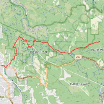
Name: 01Bib_Kalamunda to Hewett Hill Campsite trail, distance, elevation, map, profile, GPS track
Coordinates: -31.97351 116.06066 -31.95506 116.12879
Thank you for supporting this site ❤️
Make a donation
Make a donation
Gear up for your next adventure:
As an Amazon Associate, this site earns from qualifying purchases at no extra cost to you.
Other hiking, mountain biking, running and outdoor activity trails
Click on a trail to view its statistics, map and profile.
Kalamunda mtb green trails starting from camel farm
Distance: 7.7 mi • Elevation gain: 186 m • Maximum elevation: 314 m
2021 Toodyay return via Kep
Distance: 142.9 mi • Elevation gain: 1,859 m • Maximum elevation: 357 m